
So most of us are familiar with Google Maps - I know I use maps it on a weekly/daily basis to either figure out where I'm going or how long it will take me to get there. Google Maps is pretty sweet, seeing as how it will give you directions, show you traffic, give you a satellite view, street view and more. Google Earth is pretty similar - like Google Maps on steroids. They use the same maps, satellite images, etc., you just have more possibilities in the almighty Google Earth.
Whereas Maps main function is more for guidance and direction, Google Earth's function and reason for existence is more for exploring and learning by way of 3D images, clear satellite views, and more. Quite honestly, it is a little addicting. Once you've installed Google Earth, don't be surprised if you spend a significant amount of time exploring your hometown, your neighborhood, or even that city you always wanted to go but never could...until now, with Google Earth!
So how can you use this in the classroom? I thought you'd never ask:
- Learn about local geography by placing markers next to notable locations such as police and fire stations
- Explore U.S. capitals and cities
- Create tours as part of an interactive presentation
- Learn about various cultures and religions by visiting regions and places of worship all over the Earth
- Find all the sports stadiums for a specific professional league (OK, this one might be a stretch, but this is how a Phys Ed teacher could use it!)

One slight downfall to Google Earth, as of 6/14/13, you still have to download it to get the full effect. Pieces of Google Earth are incorporated into Google Maps, but the downloaded version is high-powered-well-oiled-machine-of-a-map-system.
You don't have to teach geography to have your students use Google Earth. How could use Google Earth in the classroom with your students? If you've never tried it yourself, I suggest you do - visit the Google Earth page to learn more. Download the desktop or mobile version, but fair warning - give yourself some time to explore; it's addicting!

I have rarely ventured into the "addicting" realm of Google Earth- mainly to locate my house and browse around the local area-- even that little experience, though, was very impressive. In addition, I never gave much thought to using it in my classroom- I teach math and science, where would it fit in?
ReplyDeleteAfter some thinking, my best options would be to use Google Earth in science. Perhaps, I could take my students to the coast where they could see the natural habitats of our crayfish. Maybe to the home of our Bess Beetles. Next year, we will also be studying natural resources, so if visiting specific places, like a landfill or water treatment plant were possible (i'll have to look around), we could take a trip there as well. I am excited to do some more research on this topic and how I could best use Google Earth's capabilities.
I have played with Google Earth a little but have to admit I forget about it most of the time because it is not currently something that I use in my classroom everyday. However, I thought you brought up some good ideas. As I was reading your post I couldn’t help but think of how I could really use this in my U.S. History class. We are always discussing events in different cities and locations. However, I think that one of the hardest thing for our middle schoolers to do is to visualize where things are taking place and make them real. I think using Google Earth could be a huge asset to myself and other teachers because we can take our students there on the computer screen. I think that this would help in making the material they are learning more real to them because they can see the actual grounds of Gettysburg and so on. I will definitely bring this great tool up with my co-teacher next year.
ReplyDeleteGoogle Earth with definitely help your students visualize locations! I love the idea of having the students visit the location before you start a unit or topic, and letting them explore. I think it'd be neat as well to have them visit the location after the unit with maybe some memorable landmarks from the unit. It really allows you to take your class outside of the four walls of that classroom they are in and go anywhere! In a day where field trips are becoming less and less, virtual field trips will only continue to grow, and Google Earth helps make that possible!
DeleteI would be SUPER excited to use Google Earth if I taught history/social studies. How cool would it be to virtually visit all of the places in our curriculum? Students I am sure have difficulty visualizing many of the places and topics in history. Google Earth definitely adds a more realistic element to teaching.
DeleteI love the field trip idea and instantly thought of the endless places I could take my students. They could visit countless Universities and this would fit in perfectly with our Global mission.
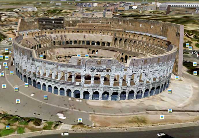
DeleteFunny you should mention Gettysburg Dion, I instantly thought about that after my first visit to DC with our 8th graders this year...and that might have been one of my top 5 places that we went. I am a visual learner and even had a hard time keeping track of it all while we were on our bus tour and then our amazing experience in the cyclorama!!! If you have not seen this yet...you should! I think that Google Earth could take our students on a background tour before they hit the battlefield...so that they can put it all in perspective.
DeleteGoogle Earth has many incredible features and is definitely easy to kill time with. The possibilities are endless when it comes to Google Earth and using it in the classroom. The fact that students can visit places they never had before is pretty neat in its self. I think Google Earth is a helpful tool when wanting students to go on a "virtual field trip," especially when covering an historic place.
ReplyDeleteUsed a virtual field during our unit on the middle east. We visited all of the iconic, religious sites in Jerusalem. The kids were able to really get a feel for the quasi geographical, religious, political importance of the city!
DeleteI love google earth. The only downfall, as Christian mentioned, is that you have to download it to your machine. Other than that, it's awesome. The ability for teachers and students to take virtual field trips is limitless. At the high school we are trying to develop global competency skills and global awareness. While we can't always travel to all the places we are studying, we can certainly take a virtual tour through google earth!
ReplyDeleteFor a previous class, I had to write a lesson/ unit plan that goes along with a class field trip to Jungle Jim's. Adding Google Earth as another resource for my students as they are researching their country would be absolutely fantastic. Such a great way to make their learning real.
Deletei agree it is difficult that use Google Earth in the classroom because it has to be download on all the devices. This is something I think our district should look into downloading on all school devices because it is such a powerful tool in the classroom.
ReplyDeleteGoogle Earth definitely has many educational possibilities. My students have used Google Earth in the past to explore landforms and to investigate the concept of night and day and seasons. I would love to explore Google Earth more in my classroom. I'm sure there are many, many options for virtual field trips!
ReplyDeleteI have toyed with Google Earth, but never given serious thought to using it as an educational tool. However, after reading your blog, I immediately started identifying ways that I could incorporate this into lessons. Just last week I finished a Sci Fi book that uses a futuristic Chicago as a setting. The book bounces all over the city and uses the rail system as another main setting. It would be very beneficial for the students to be able to view areas of Chicago and get more of a sense of "why" the author chose these locations.
ReplyDeleteVirtual field trips sound good to me... I am not a fan of the paperwork for a real one;) Also before Google Earth we couldn't go outside the surrounding states and be back in time to not miss too much of the school day. How cool would it be to assign my students a chance to visit different pieces of architecture around the world... definitely opens up our chances of exposure to a more global experience as Ben said.
DeleteJeanna, Art would be one of the perfect classes to take virtual field trips in. Think of all the unique architecture and other art pieces all over the world that your students could visit and really get to experience...almost first hand.
DeleteGoogle earth has been a godsend in the classroom, especially in regards to the geography component. Students can get an accurate feel for the size and scope of areas, and also take virtual field trips to sites- it has been a key part to our world history curriculum.
ReplyDeleteI agree with you that Google earth can truly transform the way these students see history. I don't know about others in the district but many of our students very rarely leave the west side, let alone Northern Kentucky. Google Earth starts to level the playing field for these students because they can actually get to see these places that would have otherwise just been a little picture in a book or worksheet.
Delete